Reading human history from the land
High-resolution maps of Earth reveal archaeological secrets
Ellie Kincaid • March 28, 2016
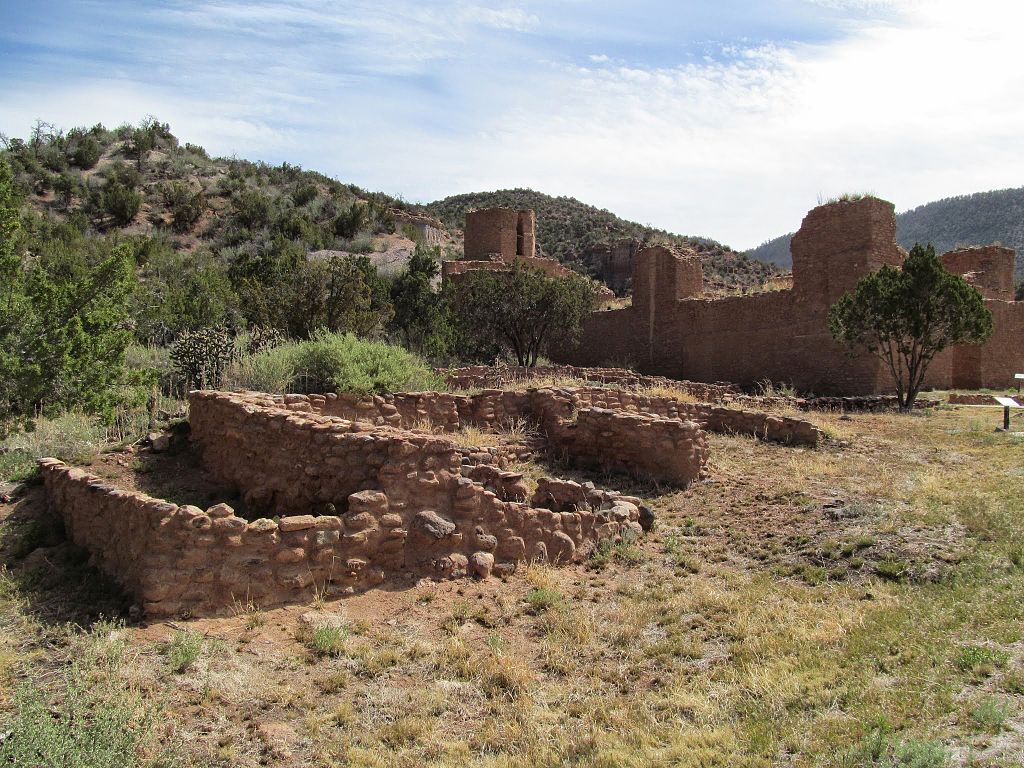
Ruins of a village in the Jemez Mountains of New Mexico, abandoned by Native Americans whose descendants still live nearby. [Image Credit: Skarz, CC BY-SA 4.0]
Long piles of rubble underneath a canopy of ponderosa pines are all that remain of the walls Native Americans in the Jemez Mountains of New Mexico built, and then left behind, sometime after the Spanish arrived. Matthew Liebmann, an archaeologist at Harvard, figured he would spend the next 20 years (the rest of his career) walking through those mountains, plotting the ruins of pueblos.
Then the United States Forest Service delivered a welcome break: A high-quality map of the earth beneath the trees. The map revealed the location and size of pueblos, which Liebmann could use to estimate the number of Native Americans who lived there. He was part of a research group studying the relationship between human activity and wildfires in the southwestern United States, and the number of people living in an area was a crucial fact to gather about human activity.
The map was “a gift from the gods,” Liebmann says. “In an instant we had access to high-resolution maps of all these sites I’ve been wanting to map for years, at levels of accuracy that were greater than I could have created myself on the ground.”
With population estimates from the maps along with other data, the research team found the link between human activity and wildfires they were looking for. As they wrote in a paper published in February 2016 in Proceedings of the National Academy of Sciences, they identified a precipitous Native American population decline between 1620 and 1640, which coincided with forest fires beginning to sweep across the landscape more frequently.
The map that proved so helpful to Liebmann’s research was the product of light detection and ranging (LiDAR) mapping technology, which renders a detailed picture of Earth’s surface beneath even the densest layers of foliage. Archaeologists using LiDAR maps have been able to peer through tree cover to the human-modified landscapes below for the first time, revealing how ancient people changed the land and uncovering connections between previous human settlements. Over the last decade, many archaeologists have started using LiDAR and other remote imaging techniques, which also do not perturb the land and aggravate contemporary wariness of invasive research techniques. Despite the prohibitive cost of gathering and analyzing LiDAR data (which requires a crosshatching plane flight with the right equipment, plus a computer to crunch the numbers), many archaeologists express excitement about the technology.
“It opens up a whole new area of research we weren’t able to do before because we couldn’t see any of these features,” says Kate Johnson, an archaeologist at the University of Connecticut who uses LiDAR to study the old stone walls, abandoned roads and other hidden imprints of New England’s previous human inhabitants.
Normal photographs taken from an airplane only record information about sunlight reflecting off Earth’s surface, or whatever grows or has been built on top of it. Instead of sunlight, LiDAR data relies on laser pulses fired from an airplane crisscrossing a landscape. The airborne system fires hundreds of thousands of pulses in a second and records how long the laser pulse takes to reflect off the ground and return to the plane. The next step is calculating the distance the laser pulse traveled, and from there the height of whatever the pulse hit.
LiDAR can see through even the densest jungle, in part because the laser pulse is transmitted and the reflection returned along the same path, says engineer and LiDAR pioneer William Carter of the National Center for Airborne Laser Mapping at the University of Houston. LiDAR systems also record multiple reflections from the same pulse, so even if part of the pulse reflects from the top of a tree while the rest keeps going, whatever reaches the ground before reflecting back to the plane still gets counted. Even lying under thick fans of palmetto leaves, some of the densest foliage there is, you can see enough chinks that allow sunlight to get through, Carter says. LiDAR finds those chinks, and a computer program uses the data to construct a three-dimensional map of Earth’s surface and all the roads, walls and temples humans have built on it.
Arlen and Diane Chase of the University of Central Florida in Orlando were some of the first archaeologists to use LiDAR in their research. When they arranged in 2009 to map the entirety of the Maya ruins of Caracol, Belize, they could finally see the true scale of the site they’d been studying for decades. The LiDAR maps revealed rainforest-covered structures that they had previously missed, and how extensively the Maya had terraced the land for farming. The whole landscape of Caracol, not just the few settlement areas archaeologists had mapped on foot, came into focus – an area the size of the District of Columbia.
LiDAR allows archaeologists to look at the landscape differently, Johnson says, especially when that landscape has been obscured under a forest canopy. In her work as a human-environment geographer in forested New England, she reads from the land the history of people interacting with the environment to produce the world as we see it, with property lines, abandoned roads and dams.
With LiDAR, that landscape becomes a visible artifact to study, opening up the scale of archaeology to include whole regions, not just individual sites. “You have this broad, sweeping view of the entire surface,” she says, much more than could be documented on foot.
Using their LiDAR map of the Jemez Mountains, Liebmann and his fellow researchers calculated the volume of rubble that remained from 18 villages in the area. From that finding, they calculated the floor space of the apartment blocks that made up the 500-year-old villages, then estimated the maximum number of people the villages could accommodate. They assumed that the villages were likely not filled quite to capacity as the 16th century began, but were somewhere between 50 to 80 percent occupied. According to their estimate, between 5,000 and 8,000 people lived in the area before Europeans first arrived in 1541.
The Native Americans cleared land around their pueblos for wood with which to build walls, heat their homes and cook. Thus, the date forests began to regrow around pueblos would provide approximate dates for when people abandoned them and weren’t around to cut down trees anymore. The researchers analyzed the growth rings of trees growing near three large pueblos to determine how long they had been growing, and estimated those pueblos were abandoned in the 1640s.
From more tree rings, the researchers found evidence that extensive fires occurred more frequently in the region after the Native American population declined. The fuel for those extensive wildfires accumulated once people were no longer clearing the land for their own needs.
Estimating population “is one of the hardest questions an archaeologist ever has to answer,” says Ann Ramenofsky, a professor emerita in archaeology at the University of New Mexico who has worked extensively in the southwestern United States. She agrees with Liebmann and his colleagues’ overall conclusion that the Native American population in the region declined in the 17th century, 100 years after their first meeting Europeans and soon after Franciscan friars established missions in the area. But she is skeptical of precise population numbers.
Those population estimates are based on the assumption that Native Americans permanently inhabited the pueblos even if they didn’t always need all the rooms, but that’s not how the people lived, Ramenofsky says. Rather, individuals inhabited pueblos in waves, leaving and returning repeatedly over time.
Exact numbers aside, the general timeline of population decline the paper lays out adds more precision to a pattern that past researchers have documented, says Doug Gann, a preservation archaeologist at the nonprofit Archaeology Southwest.
And Liebmann achieved that precision without excavation, the bread and butter of traditional archaeology. Collecting LiDAR and tree-ring data are both noninvasive archaeological techniques, which gather information a degree removed from the archaeological record, without digging it up and destroying it.
“There’s a pervasive sense in Native America that they’re tired of being studied, and noninvasive archaeological techniques treat their heritage with much more respect,” Gann says. Ramenofsky concurs. “It’s not our history,” she says, “It’s somebody else’s history.”
Excavations are very expensive to do responsibly, Gann says, and museum collections are already full of artifacts from decades-old excavations that have not yet been studied closely. LiDAR and other noninvasive techniques like photogrammetry, which renders a 3-D model of a site from overlapping photographs, allow archaeologists both to collect data for research and to preserve records of the sites they study.
In the future, LiDAR will become even more sensitive, Carter predicts. He anticipates LiDAR systems that will use multiple wavelengths of light, instead of just one like the current systems do. By comparing profiles of the amount of light various materials reflect at different wavelengths, Carter may be able to tell archaeologists the composition of structures on the ground, not just their locations and sizes. If an object reflects light in the same way the central pyramid of a city does, it may be made of the same material, and worth investigating.
But even at its current level of development, many archaeologists besides Liebmann and Johnson are finding LiDAR useful for their work in forested areas, and the maps continue to yield returns after publication.
Liebmann expects he’ll use the LiDAR map of the Jemez Mountains for the rest of his career, “any time I need to have an accurate map of what’s on the ground for what I’m working on.”
LiDAR is more than just a high-tech toy for archaeologists — it’s a tool allowing them to ask and answer questions about old landscapes, newly visible.
Filed To
Share
About the Author
Ellie Kincaid
Ellie Kincaid graduated from Washington University in St. Louis with a B.A. in English and minors in writing and biology. She’s worked on research projects ranging from multiple sclerosis to Jane Austen, and has written about medicine, health care, and animals for The Dodo and Tech Insider.
1 Comment
I would like to say great discovery by archaeologists. Finding such ancient ruins is an way to find more about human history. The LiDAR is concept seems like making easier the exploration part of archaeologists.