How traditional stormwater infrastructure contributed to ‘The Great Flood of 2014’
Interconnected infrastructure can exacerbate urban flooding, a new study suggests
K.R. Callaway • December 22, 2024

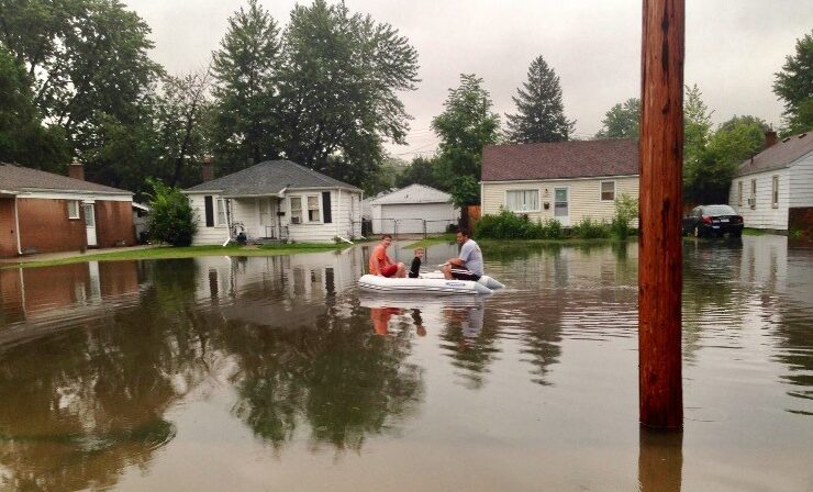
Stormwater systems are built to manage rain, but as stronger storms overwhelm these systems, they sometimes leave cities at even greater risk of flooding [Credit: U.S. Army Corps of Engineers].
With a pool of water ahead on the freeway, Michigan motorists moved toward the nearest exit on Aug. 11, 2014. Local meteorologist Paul Gross was among them, heading home after a day forecasting the weather for WDIV-TV.
His forecast predicted southeastern Michigan would be hit with heavy rain. But what Gross could not have predicted was that the deluge — over five inches of rain falling in under six hours — would compound infrastructure issues to produce a flood event that, statistically, should only occur about every 500 years.
Water covering half his tires slowed Gross’ commute. When he arrived, reports of flooding had reached the TV station. The next morning, WDIV-TV asked Gross to go to Warren, Michigan to cover what he now calls “The Great Flood of 2014.”
Like metropolitan areas around the United States, southeastern Michigan’s stormwater infrastructure — largely unchanged since this 2014 flood — is struggling to keep up with intense storms ushered in by climate change.
A recent study from researchers at the University of Michigan describes the creation of a detailed simulation of the 2014 flood. Simulations like these give researchers a more detailed understanding of how infrastructure impacts floods — and sometimes makes them worse.
Having a detailed understanding of how infrastructure has impacted flood events in the past can help give communities the knowledge to prepare for future floods and make plans to implement new infrastructure solutions.
“When we develop new solutions, they need to be placed in the context of what already exists in an urban environment,” said Valeriy Ivanov, a study author and a professor of civil and environmental engineering at the University of Michigan.
Researchers created their simulation using data on land use, rainfall and infrastructure. The simulation recreated the 2014 flood in Warren, Michigan — one of the areas hit hardest by this flood event, which caused over $1.1 billion in damage to over 118,000 homes and businesses in the region.
From this simulation, researchers found that multiple types of flooding contributed to the intensity of the flood event in Warren.
“Fluvial flooding” happens when high water levels cause riverwater to spill over into the surrounding area, and “pluvial flooding” happens when stormwater systems are just “not capable of removing water fast enough” in heavy rainstorms, Ivanov explained.
Researchers also found a third type of flooding at play — one caused by water flowing back up through the very same infrastructure put in place to drain it.
To verify their simulation’s findings, researchers looked back at pictures and videos of the flood from 2014, finding areas of persistent flooding that indicated the infrastructure there is “poorly functioning,” according to Ivanov.
Most stormwater infrastructure in the United States is “gray infrastructure” — storm drains, retention ponds and other projects that direct the flow of water around the built environment. This type of infrastructure has been around for centuries and, in many cases, is not built to withstand the severe floods that are happening more frequently due to climate change.
The infrastructure itself is not the only thing that is outdated in US flood management. The American Society of Civil Engineers has not updated its guidelines for stormwater infrastructure design since 2006, and FEMA has not updated its flood hazard map in over a decade, which the study said makes it “outdated due to climate change and land-use alterations.”
Paul Gross, the meteorologist who was caught in the flood, emphasized the role climate change plays in creating the intense storms putting stress on existing infrastructure systems.
“Global warming isn’t causing these storms, but it’s making them worse,” Gross said. “It’s higher in some places than other places, but the entire nation is seeing an increase in these extreme precipitation events.”
Gross, who has been reporting on climate change since the 1990s, said he thought of the 2014 flood as “an affirmation of what climate scientists said that we should expect.” Still, what he saw and experienced while reporting on that flood stuck with him. Mr. Gross particularly remembers a freeway underpass filled to the brim with water.
“In my entire career, never have I ever heard about police divers checking for victims on a Detroit freeway,” Gross said.
Given the grave impacts of worsening weather and struggling stormwater systems, Ivanov said he hopes his team’s research will reach policymakers and others who can “actually create solutions to prevent or minimize the damages and impact.”
In Ivanov’s view, creating detailed simulations of flood impacts is an important step in planning future flood infrastructure. But he acknowledges that the process of creating these simulations is as intensive as it is pivotal.
“Is it easy? No, it’s not. Is it feasible? I think it’s definitely feasible,” Ivanov said. “I mean, we can do it. So, the National Weather Service can do it as well.”
1 Comment
Metropolitan Detroit has had a tremendous amount of development the past few decades. Huge areas of impervious surface were built, such as manufacturing plants, parking lots, shopping malls, subdividvisions. They all force-fed, and funneled the stormwater into old pipe systems, and farmland open channel stormwater drainage ditches. Federal Projects like the 12TownsDrain of the 1960’s, flowing into the Red Run of Warren, MI – became overwhelmed.