Decoding the depths of the earth
Seismologist William Menke’s expeditions reveal what lies beneath
Katherine Ellen Foley • April 23, 2015
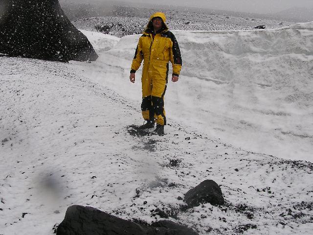
Menke frequents volcanoes like Hekla in Iceland to learn how continents take shape. [Image Credit: Bill Menke]
Seventeen years ago, William “Bill” Menke found himself in a car plummeting down the side of an Icelandic volcano. A former student, Bryndís Brandsdóttir, was in the driver’s seat when she became momentarily confused during a blizzard and accidentally drove off the main road. They fell 900 feet from the Grimsvotn volcano and caused a minor avalanche in the process. For eight hours, they waited in the cold with broken limbs for a rescue team to find them.
“My state of mind then was very peculiar, almost hyper-rational,” Menke wrote three days later. “Neither then, nor in any time in the ensuing hours before our rescue, did I experience any sort of fear or uncertainty. Survival strategies and priorities boomed into being. The world around me was crystal clear.”
Menke, now 60, has always had a clear vision of his life and work. A seismologist at Columbia University’s Lamont-Doherty Earth Observatory, he spends a lot of time braving the outdoors for his research to study the history of the Earth’s crust. At the time of the accident, he and Brandsdóttir were studying the geology of Iceland to better understand how the island formed in the first place. Their research provided a turning point in the field.
Previously, scientists hadn’t been able to collect any crustal data deeper than 10 kilometers (about 6 miles) in Iceland, so most assumed it was a relatively shallow land formation. But Menke’s findings indicated that Iceland is actually much thicker, between 20 and 40 kilometers deep, which means that it formed differently than geologists and seismologists had thought.
The data that Menke and Brandsdóttir ended up risking their lives to collect now helps seismologists save many more lives. It allows researchers to more accurately predict natural disasters like volcanic eruptions, earthquakes and tsunamis. “In seismology, you have to know thickness and physical [properties of the crust] to assess seismic hazard,” said Brandsdóttir, who now monitors volcanic activity in Iceland and its surrounding ocean for the Science Institute at the University of Iceland. The earth’s crustal activity can have huge consequences: Last year, the Mount Ontake eruption in Japan killed 47 people, while the 2010 Hatian earthquake set a record high death toll of 316,000 and the 2004 Indian Ocean tsunami killed nearly 230,000 people. Indonesia and Japan typically have the most earthquakes, while Alaska and California lead the U.S.
Most of what Menke studies is hidden below ground. But he also feels a profound connection to the visible landscape that results from those deep seismic processes: the mountains, the canyons, the ground upon which we walk. An avid outdoorsman and published photographer, he finds beauty everywhere, including the snowy cave he slept in the night before I interviewed him for this story. Wherever he goes, he can’t help but think about the glaciers and other natural processes that shaped and reshaped the terrain we experience today over hundreds of millions of years. “The connection is between … relatively humble things you can see in the world … and ideas about the history of the earth,” he explained.
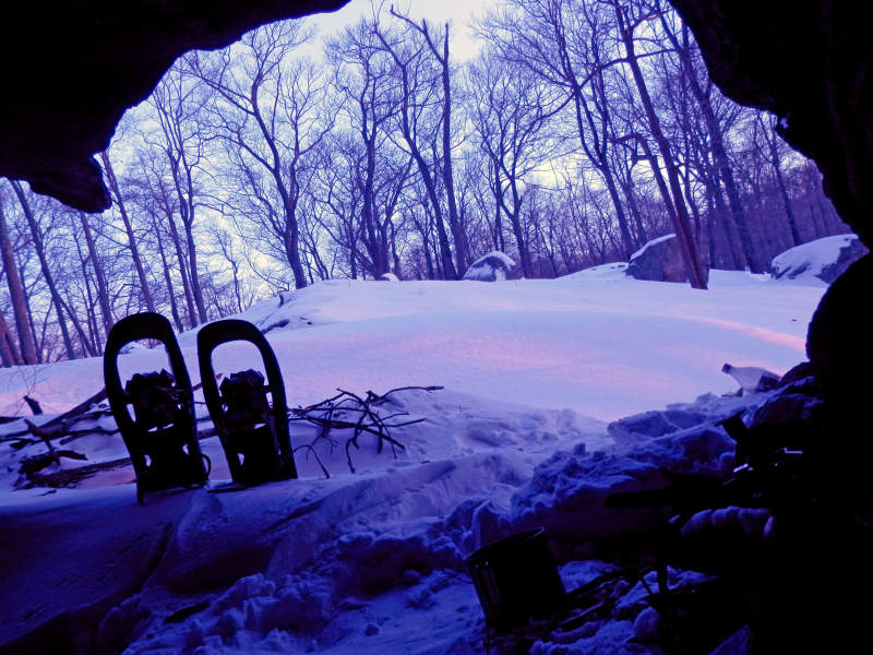
Morning view from a snowy camping trip in Harriman State Park in New York. [Image credit: Bill Menke]
Currently, Menke is studying a series of small earthquakes along the coast of New England, ranging from Maine all the way down to the northern Hudson River. At several points in the northeast, he and his students have installed geophone sensors that detect even extremely small underground movements. The tricky part is figuring out what causes those movements, since the possibilities range widely — everything from footsteps to ocean surf to earthquakes. He hopes this project will help scientists understand how the entire North American continent formed. So far, Menke and his students have detected a series of tiny earthquakes, but aren’t sure why they’ve occurred.
To Menke, unknowns aren’t problems: They’re puzzles that can be solved by thinking creatively. While obtaining his graduate degree, he was working on understanding how seismic waves travel through the Earth’s crust with his advisor, Paul Richards. At the time, computer and mathematical models were especially difficult and time consuming to produce, so Menke took a different approach: He took over one of the machine shop labs to make a model of the earth using metal and glass. He topped it with a transducer, a piece of equipment that could measure tiny movements and shakes from the metal. “He would bang away on this plate and see how far the waves traveled,” recalled Richards. “You don’t expect someone with mathematical and computational training to jump into laboratory work like that.”
Menke’s research is mostly conceptual. Many of his former students, however, fall on the practical side. Ned Field, a geologist for the U.S. Geological Survey and former student, recently launched a program to help California predict future earthquakes.
Though he retains scientific objectivity in his research, Menke is also an outspoken environmentalist who keeps a blog explaining his views. Recently, he published an open letter to the Lamont community in response to a proposal to cut down six acres of forest in order to install solar panels. Menke was outraged: Even though he acknowledges that solar panels are a good form of alternative energy, he doesn’t feel they’re worth the cost of deforestation. The university will come to a decision in the coming months. Menke, meanwhile, is keeping up the fight, arguing there is nothing green about degrading perfectly good habitat to make room for renewable energy.
Ultimately, Menke says, his goal is to gain a better understanding of the world we live in — and how we can preserve it — because he thinks it can teach us more about ourselves. Although we may tend to think of humanity as separate from nature, we’re inherently a part of it. “We are, in the end, creatures of the natural world,” he said. “Of course we have a high culture and we tend to try to discount the connections, but I think they’re very deep and we understand ourselves better when we appreciate and understand them.”
Filed To
Share
About the Author
Katherine Ellen Foley
Katherine Ellen Foley is a science writer and editor currently enrolled in New York University’s Science Health, and Environmental Reporting Program. Before moving to the Big Apple, she graduated magna cum laude from from Georgetown University’s School of Foreign Service with a B.S. in Science, Technology and International Affairs. During her time at Georgetown, she wrote pieces on science policy and explainers for Policy Mic and The Hoya. Now, she writes about a variety of topics, with an emphasis on life science and the environment. In her spare time, she enjoys long distance running, spicy Korean BBQ, and swing dancing. @katherineefoley